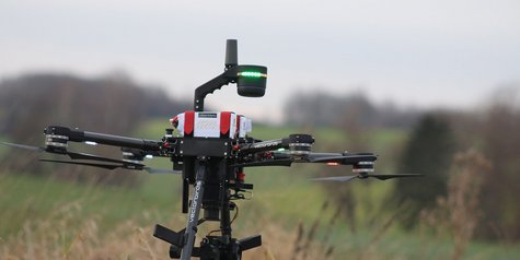
Kite75 - Surveying drone for precision RTK surveying
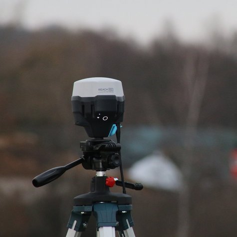
RTK measurement with Emlid Reach technology
The Kite75 mapping drone sets new standards in precise RTK surveying from the air with the integration of EMLID Reach RS2+/RS3+ technology. The mapping package, equipped with one of the most modern multi-band GNSS and NTRIP support, is further optimized by the Emlid Reach.
Position fix in seconds
The Emlid RS2+/RS3+ system provides a fixed solution in seconds and delivers robust performance even in difficult conditions. With centimeter accuracy, distances of up to 60 km in RTK and 100 km in PPK mode can be achieved.
Versatile GNSS support
The Emlid Reach RS2+/RS3+ supports GPS/QZSS, GLONASS, BeiDou and Galileo. With a variety of frequencies, including L1C/A, L2C, L1OF, L2OF, B1I, B2I, E1B/C, E5b, it ensures the highest precision in positioning.
PPP support
Recording raw position data in RINEX format enables post-processing with services such as OPUS, AUSPOS, and PPP. This means you can obtain accurate results anywhere in the world. The free PPK software Emlid Studio is available for precise post-processing.
Robust storage and LTE modem
With a generous 16 GB internal memory that allows for 160+ days of recording at 1 Hz, the Emlid Reach offers extensive storage options. The built-in energy-efficient LTE modem with 2G/3G fallback and global coverage allows independent transfer of corrections via NTRIP without relying on an internet connection on the phone.
Long operating time
The Emlid Reach offers an impressive operating time, up to 22 hours of autonomous operation when recording data and up to 16 hours as an LTE rover, even in cold weather. The ability to charge via USB-C from a USB wall charger or power bank eliminates the need for spare batteries.
With the combination of the Kite75 mapping drone and Reach RS2+ technology, high-precision surveying solutions are available for a wide range of applications.
#Kite75Mapping #ReachRS3Plus #ReachRS2Plus #PreciseSurveying #RTKTechnology #GNSS #NTRIP #MultibandGNSS #PPP #Photogrammetry #MappingDrone #Georeferencing #LTEModem #DataRecording #Surveying #PrecisionMapping #DroneTechnology #SurveyingSolution #HighPrecisionGPS #PPKTechnology #AerialSurvey #FieldMapping #SurveyorTools #MobileMapping #GNSSReceiver #DronesInSurveying
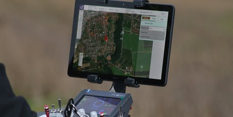
You can use the app to control all functions of the GNSS receivers, e.g. set up a base station, log RINEX data, configure the NMEA output, and monitor data. Logs are automatically recorded directly in RINEX in the internal memory. You can display a list of logs directly in the app and download them.
One appliance - versatile applications
Kite 75 surveying drone
- Mapping of big agricultural and urban areas,
- surveying of traffic systems such as railroad tracks and roads,
- construction progress documentation,
- drone-supported volume calculations in opencast mines and landfills,
- official damage documentation,
- airborne accident reconstruction,
- building inspection and BIM,
- facade surveying and documentation,
- as well as for many other applications in agriculture and forestry
Kite75 Surveying module - Specifications
Positioning
| Connectivity
|
Data
| GNSS
|
Georeferencing by drone with centimeter accuracy and few ground control points
Save time and reach hard-to-access areas
The Kite 75's high-quality mapping drone features allow you to drastically reduce the number of ground control points (GCPs), simplifying the field setup process and enabling you to accurately map even remote and hard-to-reach areas.
High-precision synchronization between camera and GNSS
On many other drone systems on the market, the autopilot triggers the camera and records the current coordinates. If the drone flies at 20 m/s and the GPS operates at 5 Hz, this means that your autopilot only receives precise position values from the GPS every 4m. This is by far not enough for precise georeferencing. In addition, there is always a delay between the triggering and the actual moment of recording.
Our Kite 75 mapping system allows for high-precision coordination between camera trigger and corresponding GPS position acquisition with 1/1000 of a second accuracy. Accept nothing less.
What happens next?
This is where we can best help you in a personal conversation.
Send an email now Go to contact form
or call us: +49 5528 999 30 50